07 March 2019

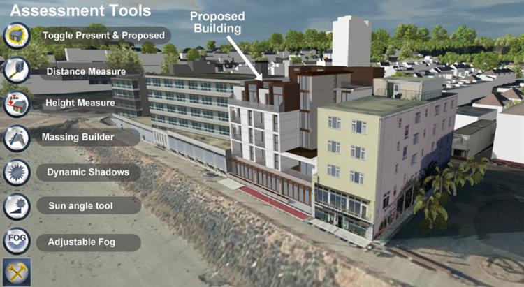
A three-dimensional online model of Jersey has been opened to help members of the public visualise how proposed developments would look.
Jersey 3D – which has been shortlisted for two planning awards – enables users to see plans for proposed developments from different perspectives. The model includes a changeable sunlight simulator to see how light and shadows are cast at any time of day, and at different times of the year.
Initially the model will only enable islanders to see development proposals, but it will become a record of Jersey’s changing built environment, with islanders able to trace the island’s development over time.
Ralph Buchholz, Principal Planner, said: “Jersey 3D is a powerful tool that provides a versatile way of showcasing development in Jersey. The Planning department and the architectural industry have been using it since 2012 to help us better understand how proposals will affect major island developments, and we have now extended and developed it to a point where it is possible for the public to use it too.
“Initially it will be an easy way for islanders to assess the visual and lighting impact of development proposals, but we’re in the process of increasing the model’s functionality to add the fourth dimension of time, so that islanders can compare developments in Jersey from 2012 onwards and see how the built environment has changed – and will change – over the years.”
Jersey 3D, which cost £50,000 to develop, was generated from aerial photography and ground-level photo surveys. It has been used to assess the impacts of significant proposed developments such as the future hospital and the Ann Court housing development.
The Minister for the Environment, Deputy John Young, said: "I very much hope this important innovation will help developers to better respect Jersey’s special environment in their designs, and our planning officers to better assess the impact of new developments against their immediate surroundings.
“I see it as important as part of my commitment to try to maintain the quality of Jersey’s environment, whether the urban fabric of our built up settlements, or the surrounding landscape, including the green backdrop zone intended to protect views inland from the sea. The model will particularly help to better assess the impact of development on immediate neighbours to avoid unreasonable impact on neighbouring amenities."
The model has been shortlisted for a tech award at the Royal Town Planning Institute Awards for Planning Excellence in recognition of its contribution to the planning process. It has also been shortlisted for the Information Technology Association Galway (ITAG) Excellence Awards, which recognise and celebrate innovative digital projects.
Mr Buchholz said: “As far as we’re aware, Jersey 3D is the world’s first 3D planning assessment system – it represents genuine world-class innovation that has been developed by the Government of Jersey and our digital technology partners, and I’m delighted that its contribution to the planning process has been recognised.
“The awards that the model has been shortlisted for – the Excellence in Tech within Planning Practice Award at the Royal Town Planning Institute, and the Digital Project Award at ITAG – recognise projects that harness digital capabilities in order to innovate and improve processes, which is exactly what Jersey 3D does.”
The ITAG award ceremony will take place in Galway later this month, and the Royal Town Planning Institute ceremony will be held in London on 24 April.